1. Introduction
Contouring is an important aspect of surveying which basically involves the determination of the elevation of various points on the ground followed by fixing the points of the same horizontal positions in the contour map.
A contour may be defined as an imaginary line that passes through the points of equal elevation. It is a line in which the surface of the ground is intersected by a level surface.
In contouring, every fifth contour line is made dark. It must be ensured that the characteristics of the contour are considered while the contour lines are drawn.
The primary objective of contouring is the preparation of contour maps which serves the following purposes:
1. It helps to study the nature of the terrain or ground of the proposed site.
2. It is essential for determining the profile along the section line and working out the depth of cutting and filling during the road alignment survey.
3. It is important for determining the location of bunds, dams and identifying the flood level.
4. It is inevitable for route survey of roads, canals etc and also for balancing the earthworks.
2. Characteristics of Contour
The main characteristic of the contour can be listed as follows:
1. The horizontal distance between any two contour lines indicates the amount of slope and varies inversely on the amount of slope.
2. Two contours of different elevations never cross each other except in the case of an overhanging cliff.
3. Contours of varied elevations never unite to form a single contour except in the case of a vertical cliff.
4. Contours that are close to each other depict a steep slope whereas the contours drawn apart depict a gentle slope.
5. The equally spaced contours depict a uniform slope. When the contours are drawn parallel, equidistant and straight, such contours indicate inclined plane surfaces.
6. A contour line must close itself but may not necessarily be within the limits of the map itself.
7. Contour at any point is perpendicular to the line of the steepest slope at that point.
8. Irregular contours indicate uneven surfaces.
9. The same contours must appear on both the sides of a ridge or a valley.
10. Contours do not have sharp turns.
11. Approximately concentric closed contours with decreasing values towards the centre indicate a pond.
12. Approximately concentric closed contours with increasing values towards the centre indicate hills.
13. Contour lines with U-shape with convexity towards lower ground indicate ridge.
14. Contour lines with V-shaped with convexity towards higher ground indicate valley.
15. Contours of different elevations cannot cross each other. If contour lines cross each other, it shows the existence of overhanging cliffs or a cave.
16. Contours do not pass through permanent structures such as buildings.
3. Methods of Contouring
Basically, there are two methods of contouring which are briefly described below:
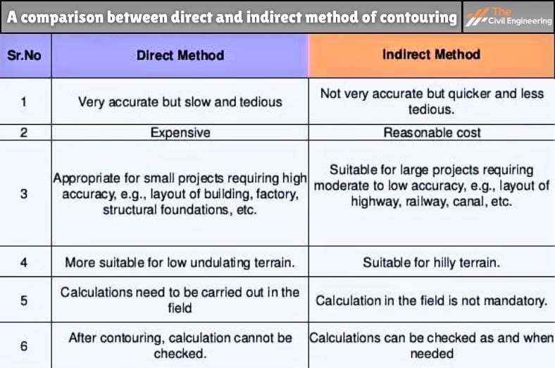
1. Direct Method of Contouring
In the direct method of contouring, the points of equal elevation are determined directly on the field.
The horizontal control of the points is then found out with the help of a plane table, theodolite or chaining.
In this method, firstly, the reduced level of the various selected points is on a contour line are obtained and the position of the points are located.
These points are thus duly joined in order to obtain the contours.
This method is highly suitable for small areas where high accuracy is required.
The drawback of this method is that it is relatively slow and tedious.
2. Indirect Method of Contouring
In the indirect method of contouring, some suitable guide points may not necessarily lie on the contour.
The indirect method of contouring can be categorized into the following methods:
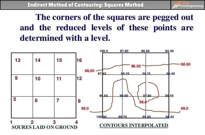
a. Squares Method:
Squares method of contouring basically involves the division of the area to be contoured into a series of squares, the corners of which define the points to be observed.

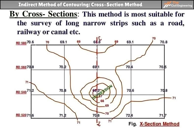
b. Cross-Section Method:
In the cross-section method of indirect contouring, suitably spaced sections are duly set out from the traverse lines such as the centre line of roads, railways etc and then the observations are made on the different points of each section generally with the help of a theodolite.

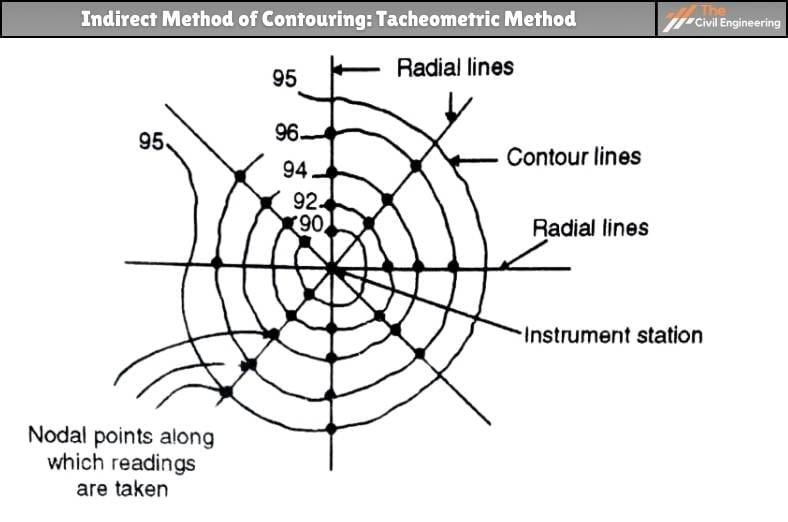
c. Tacheometric Method:
Tacheometric method of indirect contouring involves the setting out of the radial lines by making different angles with respect to a reference line.
On each of the radial lines, the tacheometric readings are then taken on the levelling staff kept at different points.


| Read More: Land Surveying |
| Read More: Grades of Concrete |

