
A plan may be defined as the graphical or symbolic representation of how a building or structure will look after completition of construction.
It is extensively used by Architects, Engineers, and Contractors in the construction industry.
A plan can act as a medium of communication between the various parties involved in the construction as it can depict the concept and design of the structure to be constructed.
The primary objective of the plan is to provide an idea of the entire structure construction. It is also essential in estimating the total budget required for the construction.
2. What is a Site Plan?
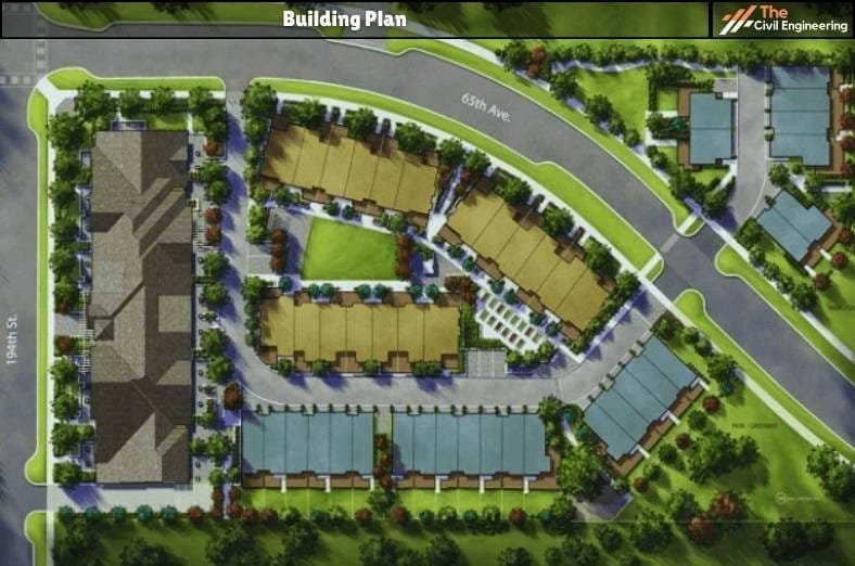
The site plan can be defined as a large-scale drawing that depicts the overall extent of a site for the construction of new structures or the development of existing structures.
In simple terms, the site plan is the symbolic representation of the arrangement of a building/structure and the associated utilities on a site.
The site plan essentially includes the property lines, existing boundaries, access to the site, and all the existing nearby structures that must be considered during the design.
It represents the top view of a property within a site suitably drawn to scale.
The site plan must also clearly depict the existing household connections, service connections, and utilities such as water supply lines, drainage lines, sewer lines, underground cables, electrical lines, communication cables, etc.
Thus, the site plan includes a set of construction drawings that are necessary for the planning, improvement, and development of a site or property.
The site plan must be made following the existing bye-laws and local development codes. This is because the site plan also serves as a legal agreement for the permission of the concerned authorities to construct it.
3. Suitable Scale for Preparation of Site Plan
The selection of scale for preparing the site plan is mostly done based on the size of the project.
In most cases, the scale of the site plans ranges from 1:500 to 1:200.
It is a common practice to use small scales for large projects and large scales for small projects.
4. Elements Depicted in a Site Plan
The major elements that are shown in a site plan can be enlisted as follows:
a. Boundary lines and the property lines.
b. Clear outlines of the proposed structures and buildings as well as the outlines of any existing structure.
c. Distance between the proposed structure and other adjoining and nearby structures.
d. The setbacks (i.e. the distance of the proposed structure to the property line.)
e. The parking spaces, parking lots, and driveways.
f. Adjoining and nearby streets and roads.
g. Existing utility and service lines.
5. Information to be Included in Site Plan
The following information must be included are as follows:
a. The title block comprises the name of the project, the type of drawing, the name of the person who prepared the plan, the status of the project, the revision number, and the scale used for the drawing.
b. In case of revisions; notes depicting the changes made must be included. The notes are usually highlighted.
c. The directional orientation i.e. north pointing arrow must be shown.
d. The dimensions of the drawings must be included.
e. The chief materials used can also be included.
f. The property lines or the boundaries of the site along with the adjoining streets and properties must be shown.
g. The location of the site for the proposed construction must be indicated concerning the surroundings.
h. Existing trees, plants, and environmentally essential elements, or restricted spaces such as public plantations must be included.
i. The parking space with clear dimensions along with the traffic flow and related signs must be shown.
j. The existing streets, roads, and pavements along with the easements such as the right of way, right of support, etc must be included.
6. Additional Information Included in Site Plan
Mostly, when the site of the proposed construction is complex, additional information must be included in the site plan.
The general site plan may be prepared along with the structural plan of the site, site lines, site history, landscaping drawings, existing topography, geology, etc.

Some of the additional information that can be included in the site plan are as follows:
a. Any existing property or building which has to be demolished must be included in the site plan.
b. The layout of the existing utility lines and service lines such as drainage lines, sewer lines, electricity cables, etc must be shown.
c. The extent of excavation and earthworks necessary including the cutting and filling must be included.
d. The fencings, gates, walls, and other external elements such as fire hydrants, municipal litter bins, etc, if any can be included in the site plan.
5. References1. Content Filter & Authenticity Checking Team, The Civil Engineering (Our team checks every content & detail to maintain quality.) |
Read More: Building Plan
Read More: Hempcrete ( Concrete made using Hemp Hurd)